Lunes, Pebrero 18, 2013

Eden Nature Park in Davao City


Eden Nature Park and Resort


Eden Nature Park and Resort in Toril, Davao City

In 2007, I brought along a long-time friend and trusted associate, Tom Hilado of Manila for a month-long vacation with my wife, Grace, and daughter, Jamie in Davao City. Tom is one of those adventurous types of a guy who simply wonders aimlessly about in a totally unfamiliar place, always ready to try out just about anything - from the local street food, to the most exotic delicacy; from a wholesome joint, to the not too naive cocktail bar; from a decent health spa, and, to his utter surprise and amazement, to a downtown massage parlor whose masseuse did not only know how to massage but instead offered a different kind of "service" . . . . Being a decent, and well-bred fellow my friend, Tom is, he quietly left the place in question, and immediately took one of the popular rides in the City called the "habal-habal", a two-wheeled motorcycle usually ridden way beyond its passenger capacity, (Habal-habal can unbelievably carry 5 to 6 passengers effortlessly, and can only be found, where else but, in the streets of the Philippines particularly in Mindanao), and in an effort to discover what Davao City can offer to this insatiable adventurer, Tom found himself at the very doorstep of Eden Nature Park and Resort in Toril, and spent the entire afternoon wandering about the resort. It was already past the hour of 8:00 o' clock in the evening when Tom came back home to our rented abode in Catalunan Grande, and, over dinner, vividly narrated in detail his adventure for the day. Apparently, Tom immediately fell in love with the resort the moment he set foot to Eden Nature Park, and has never lost that emotional grip since. 


Wide pathway leading to the Resort

Today, in our usual weekend discussions and views of current events over one too many bottles of beer back at my residence in Manila, Tom would reminisce his fond escapade to the mountains of Eden Nature Park, and I, in turn, as a good friend to him, patiently bear his litany of superlatives about this paradise in the mountains of Davao City called Eden Nature Park and Resort up to the very last drop of beer. Naturally, Tom hopes to be back in Davao City in the not too distant future, on a sentimental journey to Eden Nature Park.

Dedication of this special post to my good friend, Tom Hilado, is therefore, in order.


Entrance to Eden Nature Park

Eden Nature Park and Resort is one of the most frequented destinations in Davao City by foreign tourists and local visitors alike. Right at the very foot of Mount Talomo in Davao City's District of Toril, the Resort is quietly nestled on a sprawling expanse of 80 hectares of terraces carved out of the mountain slope,  about 2,650 feet above sea level, and where over a 100,000 fully-grown pine trees, and another 100,000 towering forest trees are spread all over the area, providing a safe sanctuary to wild birds nestled freely on its branches, and forming a huge canopy of leaves that serve as a protective cover to other trees and plants flourishing wildly into a secondary forest of flora and fauna.

Unknown to many, Eden Nature Park is 95% man-made resort. Discovered sometime in 1971, the resort was once a logged-over area covered only by a blanket of wild grass. Today, the Eden Nature Park and Resort has become a truly world class facility that offers  personalized tours and services to its resort guests. It's modern facilities and amenities include a 62-room hotel replete with non-smoking areas, and beautifully furnished with writing desks, cable televisions, shower rooms, mini bars and kitchenettes; a souvenir shop, laundry services, dry cleaning, meeting facilities, and a restaurant. There are also leisure and sports facilities such as pool for kids, a kids' club, an outdoor pool, and many flower gardens.


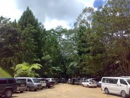
Spacious parking lot for the Resort's guests


Welcoming guests to the Eden Nature Park at the Day Tour Center

Places of interests in Eden Nature Park and Resort include:


Day Tour Center

The Day Tour Center is the information central of the day's activities of the resort where guests register here for day packages, guided tours, or special day events.


Guided Shuttle Tour 

The Resort offers a 45-minute guided shuttle tour for those who are eager to get a glimpse and a quick orientation of the Resort's endless attractions and amenities. Availability of the shuttle tour, however, comes on a first-come-first-served basis.
Map of Eden Nature Park


Eden Nature Park's signage


Souvenir Shop

The Souvenir Shop features a variety of native handicrafts, and trinkets made in Davao, as well as souvenir items that carry the Eden label. It is conveniently located just across the Day Tour Center.


At the Souvenir Shop


Outside the Souvenir Shop


Inside the Souvenir Shop


On display are the many native handicrafts and trinkets made in Davao
as well as souvenir items that carry the Eden label


St. Michael, The Archangel Chapel

St. Michael, The Archangel Chapel  is located near the entrance of the Resort, and is a popular venue for weddings.


Inside the Chapel


The Amphitheater

The Amphitheater is a multi-function open area of manicured grass, perfect for mass, garden weddings, parties, and other social, and business events. It provides magnificent panoramic view of Davao City, and the Gulf of Davao.


The Amphitheater with Jade vine covering the columns


Breathtaking view of Davao City and the Gulf of Davao


An Albino Peacock


Garden of Eden with the Statue of St. Francis of Assisi

The Garden of Eden is a perfect place for prayer, or simply to wander about in the Garden with its cool and tranquil ambiance amid a rich variety of colorful plants beautifully arranged.


Entrance to the Prayer Garden


Wide pathways


Mountain Trail

This is one site in Eden Park where brisk walkers, hikers, and joggers enjoy nature's richness and the rejuvenating air filled with the whiff of towering pine trees as they ramble through the magnificent ravine trails and wide boulder pathways, while listening to the chirping of wild birds, and the rustling of leaves of pine trees and forest trees. 


Wide pathways


Rainbow Pass


Man-made Matino Waterfalls


Vista Playground


Adventure ride called Indiana Jones
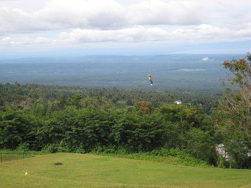
Eden Park's Zipline


Mayumi's Wishing Well

Mayumi's Wishing Well is filled to the brim with floating hibiscus in colorful array.


A closer look of floating hibiscus in colorful array


Lola's Garden

Lola's Garden is one of the beautiful spots in the Garden, and is frequented by guests for photo shoots. Various herbs and vegetables are organically grown here.


Various herbs and vegetables are organically grown
at the Lola's Garden

Eden Orchard

Eden Orchard houses rows of lettuces grown in hydroponics - a method of growing plants in nutrient-enriched water instead of soil,  and is 100% pesticide free.


Hydroponics Garden


Eden Fishing Village

Tilapia and Hito are a day's prized catch in the Fishing Village.


Welcome signage to the Fishing Village


Pool of waters


Manicured grass in the Garden


visit davao city phillipines


Davao City

From Wikipedia, the free encyclopedia
Davao City
Dakbayan sa Dabaw
Lungsod ng Dabaw
—  Highly-Urbanized City  —
City of Davao
From top, left to right : San Pedro Cathedral, Commemorative Monument of Peace and Unity,Abreeza Ayala Business Park, Landco Pacific Tower,Ateneo de Davao UniversityDavao Chinatown

Seal
Nickname(s): Crown Jewel of Mindanao
Durian Capital of the Philippines
EcoAdventure Capital of the Philippines
City of Royalties
Motto: Love, Peace, and Progress
Map of Davao City and the province of Davao del Sur
Davao City is located in Philippines
Davao City
Map of Davao City and the province of Davao del Sur
Coordinates: 7°3′52″N 125°36′28″ECoordinates7°3′52″N 125°36′28″E
CountryPhilippines
RegionDavao Region (Region XI)
Districts1st to 3rd Districts of Davao City
Barangays182
City TypeHighly Urbanized City
Incorporated (town)1848
Incorporated (city)March 16, 1936
FounderDon Jose Cruz de Uyanguren of Guipuzcoa,Spain
Government
 • MayorSara Z. Duterte-Carpio (LP/Hugpong sa Tawong Lungsod)
 • Vice MayorRodrigo R. Duterte(LP/Hugpong sa Tawong Lungsod)
Area
 • Highly-Urbanized City2,444 km2 (944 sq mi)
 • Urban293.78 km2 (114.57 sq mi)
 • Metro4,041.39 km2(1,560.39 sq mi)
Elevation22.3 m (73.2 ft)
Population (As of 2011)
 • Highly-Urbanized City1,530,365 (estimated)
 • Rank4th
 • Density626.17/km2 (1,621.8/sq mi)
 • Urban1,397,233 (95.42%)
 • Metro2,274,913
 • Metro density560/km2 (1,500/sq mi)
 • Agglomerated LGUs2,854,711
DemonymDavaoeño
Time zonePST (UTC+8)
Area code(s)082
LanguagesCebuanoChinese,Tagalog and English
Websitewww.davaocity.gov.ph
The City of Davao (CebuanoDakbayan sa DabawTagalogLungsod ng Dabaw) is a city in MindanaoPhilippines. It is a part of Metro Davao, the third most populous metropolitan area in the country. The city serves as the regional center for the Davao Region.
Davao is also the largest city in the Philippines in terms of land area. It has an estimated population of 1,530,365 as of 2011. The City Mayors Foundation ranks Davao City as the 87th fastest growing city in the world, and it has been listed by the FDi magazine as the 10th "Asian City of the Future" together with two other Philippine cities – Quezon City as 7th and Cebu City as 8th.[1]
The city is located near beaches, mountain resorts, and diving spots. The highest peak in the Philippines, Mount Apo, is located in the city. Davao has been awarded by the Department of Tourism as the "Most Livable City" in the Philippines in 2008.[2]

Contents

  [hide

[edit]History

[edit]Name's history

Local historians of Davao claim that the word davao came from the phonetic blending of the word of three Bagobo subgroups when referring toDavao River, an essential waterway which empties itself into Davao Gulf near the city. The aboriginal Obos who inhabit the hinterlands of the region called the river, Davoh; the Clatta or Guiangans called it Duhwow, or Davau, and the Tagabawa Bagobos, Dabu. To the Obos, the word davoh also means a place "beyond the high grounds", alluding to the settlements located at the mouth of Davao River which were surrounded by high rolling hills. When asked where they were going, the usual reply is davoh, while pointing towards the direction of the town. Duhwow also refers to a trading settlement where they barter their forest goods in exchange for salt or other commodities.

[edit]Spanish conquest and administration

[edit]Conquest of the area

Spanish influence was hardly felt in the Davao until 1848, when an expedition of 70 men and women led by Don José Cruz de Uyanguren, a native of Vergara, GuipuzcoaSpain, came to establish a Christian settlement in an area of mangrove swamps that is now Bolton Riverside. Davao was then ruled by a chieftain, Datu Bago, who held his settlement at the banks of Davao River (once called Tagloc River by the Bagobos). The chieftain was the most powerful datu in the area during that time. When Uyanguren met with the Mandaya chieftain Datu Daupan, he allied with the chieftain to help defeat Datu Bago, who treated their neighbors Mandayas as tributary barangays. Uyanguren attempted to defeat Datu Bago, but failed when their ships were outmaneuvered in crossing the narrow channel of the Davao River bend, where the Bolton Bridge is now located. Three months after the battle, he was forced to build the causeway that connects to the other side of the river, but Datu Bago's warriors raided the causeway and harassed the workers. However, a few weeks later after the battle, Don Manuel Quesada, Navy Commanding General ofZamboanga, arrived with a company of infantry and joined in the attack against Datu Bago’s settlement.

[edit]Establishment of the town

After Uyanguren defeated Datu Bago, he renamed the region Nueva Guipúzcoa and founded the town Nueva Vergara, which was Davao, in the year 1848, in honor of his home in Spain, and became its first governor. He himself was reported to have peaceful conquest of the entire Davao Gulf territory at the end of the year, despite lack of support from the Spanish government in Manila and his principals during the venture. He attempted to make peace with the neighboring tribes—the Bagobos, Mansakas, Manobos, Aetas, etc. -- to urge them to help develop the area; his efforts to develop the area, however, did not prosper.

[edit]The region under a new governor

By 1852, due to intrigues by people in Manila dissatisfied with his Davao venture, Marquis de Solana, under Governor General Blanco's order, took over Uyanguren's command of Nueva Guipúzcoa (Davao) Region. By that time, the capital town, Nueva Vergara, which is Davao, had a population of 526 residents and while relative peace with the natives prevailed, population expanded very slowly that even in the census report of 1855, theChristian inhabitants and converts increased to only 817, which included 137 exempted from paying tributes.
In 1867, the original settlement by the side of Davao River (end of present Bolton Street) was relocated to its present site with the Saint Peter’s church (now San Pedro Cathedral) as the center edifice on the intersection of San Pedro and Claveria Streets.
In the meantime, in response to the Davaoeños persistent demands, Nueva Vergara was renamed "Davao". The name is derived from its Bagobo origins: the Tagabawa who called the river "Dabo", the Giangan or Diangan who called it "Dawaw", and the Obo who called it "Davah", with a gentle vowel ending, although later usage pronounce it with a hard "v" as in "b". The pioneer Christian inhabitants of the settlement understandably were the proponents behind the official adoption of the name "Davao" in 1868.
The arrival of a group of three Jesuit missionaries in Davao in 1868 to take over the mission from the lone Recollect priest in the Davao Gulf area, marked a systematic and concerted effort at winning souls over the native inhabitants to the folds of Christian life. Through their zeal and frequent field work, the Jesuit fathers gradually succeeded in winning souls over the different indigenous tribes to live in reducciones, or settlements, thus easily reached for instructions in Christian precepts and practices.
By the 1890s, even the Muslims were starting to become Christian converts, through the efforts of their own datus, Datu Timan and Datu Porkan, although many others remained steadfast in their faith to Islam. Fr. Saturnino Urios who labored among the Moros of Hijo in 1892 further swayed the latter’s faith that led to the splitting of their population. Those who wanted to live among the Christians left Hijo and were resettled in Tigatto, Mawab, and Agdao, under the supervision of Don Francisco Bangoy and Don Teodoro Palma Gil, Sr. respectively. These separatist groups generally refer to themselves today as Kalagans.

[edit]United States of America administration

[edit]Initial growth of the town

A few years after the American forces landed in 1900, private farm ownership grew and transportation and communication facilities were improved, thus paving the way for the region's economic growth.
During the early years of American rule which began in late December 1898 the town began to mark its role as a new growth center of the Philippines, which it will be a city for the next 38 years. The American settlers, mostly retired soldiers and investor friends from ZamboangaCebuManila and the U.S. mainland immediately recognized the rich potential of the region for agricultural investment. Primeval forest lands were available everywhere. They staked their claim generally in hundreds of hectares and began planting rubber, abaca and coconuts in addition to different varieties of tropical plants imported from CeylonIndiaHawaiiJava and Malaysia. In the process of developing large-scale plantations, they were faced with the problem of lack of laborers. Thus, they contracted workers from Luzon and the Visayas, including the Japanese, many of whom were former laborers in the Baguio, Benguet road construction. Most of these Japanese later became land-owners themselves as they acquired lands thru lease from the government or bought out some of the earlier American plantations. The first two decades of the 20th century, found Davao one of the major producers of export products --- abaca, copra and lumber. It became a regular port of call by inter-island shipping and began direct commercial linkages abroad - US, Japan, Australia, and many other countries. Some 40 American and 80 Japanese plantations proliferated throughout the province in addition to numerous stores and business establishments. Davao saw a rapid rise in its population and its economic progress gave considerable importance to the country’s economy and foreign trade.
Japan-town, Davao City circa 1930s.
Japanese entrepreneur named Kichisaburo Ohta was granted permission to exploit vast territories which he transformed into abacá andcoconut plantations. The first wave of Japanese plantation workers came onto its shores in 1903, creating a Little Japan. They had their own school, newspapers, an embassy, and even a Shinto Shrine. On the whole, they established extensive abaca plantations around the shores of Davao Gulf and developed large-scale commercial interests such as copra, timber, fishing and import-export trading. Filipinos learned the techniques of improved cultivation from the Japanese so that ultimately, agriculture became the lifeblood of the province's economic prosperity.

[edit]From town to city

Because of the increasing influence of the Japanese in the trade and economy of region, on March 16, 1936, Romualdo Quimpo, the congressman from Davao filed Bill no. 609 and was subsequently passed as Commonwealth Act No. 51 creating the City of Davao from the Town of Davao (Mayo) and the Guianga District. The bill further called for appointments of the local officials from the president.[3]
Davao was formally inaugurated as a chartered city on October 16, 1936, by President Manuel L. Quezon. The City of Davao then became the provincial capital of the then undivided Davao Province. It was one of the first two towns in Mindanao to be converted into a city, the other being Zamboanga. By that time the city's population was 68,000.

[edit]The city at war

On December 8, 1941 Japanese planes bombed the city. Japanese occupation started in 1942.
In 1945, American and the Philippine Commonwealth forces liberated Davao City from Japanese forces. The longest and bloodiest battle during the Philippine Liberation occurred in the city during the time of the Battle of MindanaoWorld War II brought considerable destruction to the new city and numerous setbacks to the earlier economic and physical strides made before the Japanese occupation. Davao was among the earliest to be occupied by the invading Japanese Forces, and they immediately fortified the city as the bastion of Japanese defense. It was subjected to constant bombing by the returning forces of Gen. MacArthur, long before the American Liberation Forces landed in Leyte in October 1944.

[edit]Philippine administration

After the Second World War, though the forces of the Empire of Japan inflicted a heavy toll over the city and its citizens during the war, the city still continued on its economic growth. Its population rose to 112,000 in 1946; its Japanese inhabitants, which consist 80% of the population of the city that time, were incorporated to the Filipino population; some of them are totally expelled from the country. The city resumed its role as the premier agricultural and economic hub of Mindanao. Logs, lumber, plywoodcopra and banana products gradually replaced abaca as the major export product.
Thirty years later, in 1967, the Province of Davao was subdivided into three independent provinces, namely Davao del NorteDavao del Sur, and Davao Oriental. The City of Davao was grouped with Davao del Sur and was no longer the capital. However, it became a center of trade for Southern Mindanao. Over the years, Davao has become an ethnic melting pot as it continues to draw migrants from all over the country, lured by the prospects of striking it rich in the country's second largest city.
From the 1970s to present, Davao became the Regional Capital of Southern Mindanao and with the recent reorganization, became the regional capital of the Davao Region (Region XI) and the Highly urbanized city in the Province of Davao del Sur.